This walk is an absolute classic, and you can see the reason: it has the ingredients of great views without climbing and wonderful woodland on the return. It is short and easy and hugely rewarding, especially recommended for those who want a pleasant half-day in the South Downs or maybe those who want an introduction to this part of England. This walk is perfect with your dog too. It is taken from www.fancyfreewalks.org.
1. Starting at the Whiteways Lodge car park, walk to the end, parallel with the main road on your right, on a grassy path, passing a water trough. Keep to the main path as it winds through trees and runs beside a field on your right. Always stay beside the field, ignoring a waymarker on your left, bearing right at another waymarker. After nearly 1 km, your path comes out to a crossing path by a 4-way fingerpost. Turn left on a wide track, part of the South Downs Way long-distance footpath.
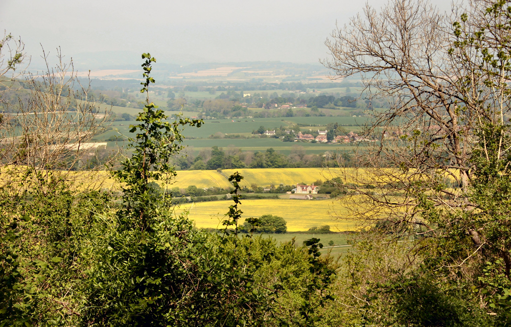
2. The path quickly breaks free of the trees and runs in the open with great views all around. Ahead to your left is Bignor Hill, recognisable from its two transmitters, and on the left Houghton Forest, both on your route. The sea at Bognor is visible behind you. Stay on this ancient flint-lined trackway up to the top of Westburton Hill where you have views north towards Petworth and Black Down (seen end-on). You pass some large corrugated barns and, just after them, you come to a junction of paths.
3. Turn left at a fingerpost on a track which immediately bends right. At the next fingerpost, the track veers left uphill. At the top of the slope, turn sharp right as directed by the fingerpost. The path gradually rises with great views on your right. You pass Toby’s stone, a mounting block dedicated to the master of the Cowdray Hunt, and a National Trust sign for Slindon Estate. This section is also used (in reverse direction) by the Bignor walk in this series. Finally you come to Bignor Hill where you meet a NT noticeboard, a tarmac lane and a car park. Straight ahead is a very large 4- way fingerpost, partly written in Latin (Noviomagus Reginorum is present day Chichester).
4. Pass to the right of the big fingerpost, immediately fork left at another fingerpost, but at once leave the track by going straight ahead through a small wooden gate. There is a shorter way back but you’ll want to linger just a little on this beautiful Bignor/Bury Hill. Keep to this pleasant grassy path with woodland close by on your left. In 80m, fork left, as directed by a marker post. In another 100m unexpectedly you arrive at a 4-way fingerpost. Turn sharp left here through a wood, shortly going through a small wooden gate. Once out of the wood, keep ahead, joining a track, passing a seat and reaching another fingerpost at a junction of paths.
5. Go straight over the junction with the woodland on your right. Your path goes past a clearing, over a farm track and finally into Houghton Forest at a large Forestry Commission sign. In 250m, avoid a left turn at a marker post and avoid another in 500m. Rather mysteriously, this section of Houghton Forest is called “The Denture”. Your path goes through a small clearing and meets a 3-way fingerpost with a junction on the right: go straight on regardless. About 200m further, at another small clearing there is another fingerpost indicating a fork: take the left fork.
6. In about 300m, there’s another waymarker as your path goes over a narrow crossing path. The chalky path descends gently for another 350m through a fine section of forest with ash, yew, maple and finally beeches. [Apr 2019: you need to clamber over a large fallen tree.] Your path crosses a wide track and, in 40m, meets another track. Veer right to join this track. Follow this stony path, slightly uphill, under tall beeches, and follow it for ½ km, avoiding any minor turnings off. Your path goes past what looks like a bank of earth but is actually a tree trunk covered in earth. Keep straight ahead all the time. Finally the path comes out to the Whiteways Lodge car park next to the café and loos, where the walk began.

DISTANCE: 5½ miles
MAP: OS Explorer 121 (Arundel)
START: The walk begins at the free Whiteways Lodge car park in West Sussex, just north of Arundel on the A29. The postcode is BN18 9FD. The car park closes at 8pm or perhaps at dusk in the winter (always check the notice at the entrance). It has a café and wc.
Image: Overlooking New Barn and Sutton to Barlavington Hanger on the horizon (Peter Jeffery).


